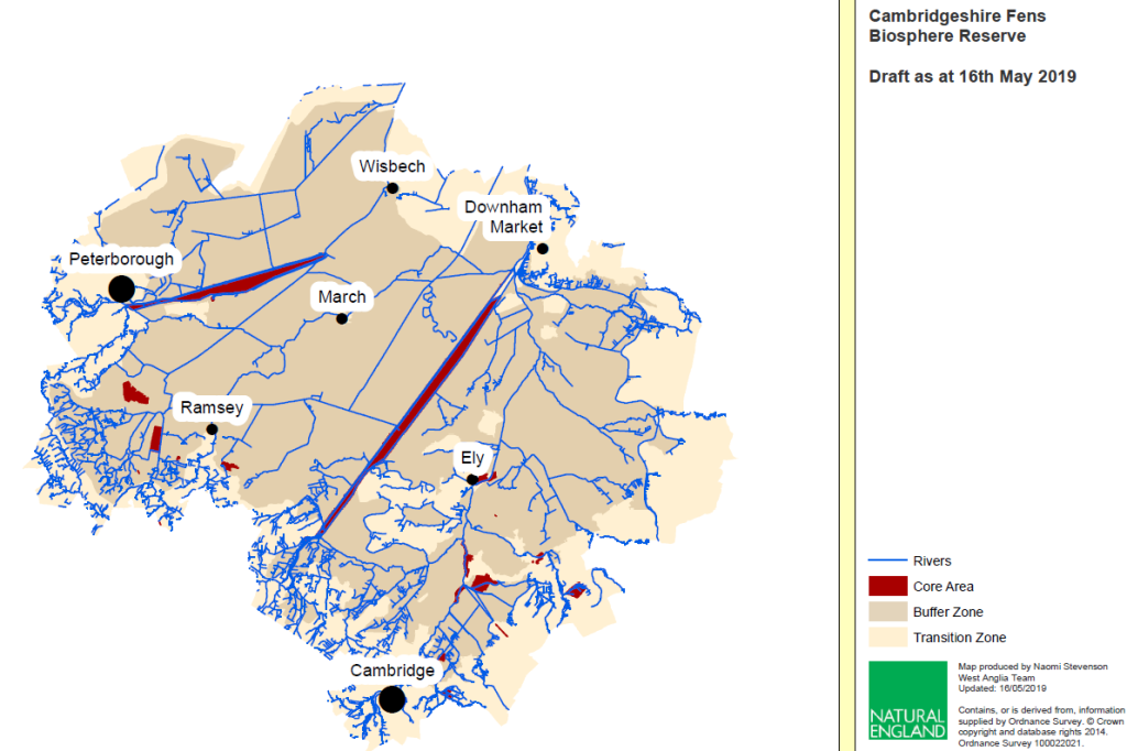
Below is a draft map of the area currently being considered for Biosphere Status. Please note that this is not a final map, it is a work in progress.
Explanatory note on zones:
The Core Zone: these are the sites of specific conservation value. They are already legally designated protected areas and are carefully managed to enhance their wildlife.
The Buffer Zone: this area surrounds the Core Zones; the Biosphere will support activities in this area which are strongly focused on linking people, science and conservation to support the Core Zones. These activities could include trialing new agricultural crops and techniques, encouraging communities to develop new spaces for nature or looking at how water resources can be managed on a landscape scale.
In the UK this Zone is often already designated as an Area of Outstanding Natural Beauty or National Park, in the Fens Biosphere this is not the case.
The Transition Zone: this is the outer zone which often contains the towns, cities and villages of the Biosphere. Because this is where most people live, activities will focus on ensuring that resident needs (housing, jobs, recreation and so on) are sustainable and if possible benefit wildlife and the environment.
Once an area has achieved Biosphere status it is known as Biosphere Reserve but this does not mean that it is a protected area.
This map has been kindly produced by Natural England with input from the Fens Biosphere Working group.
Draft area
In order for UNESCO to be able to designate the Fens Biosphere as a UNESCO Biosphere Reserve, a range of partners have been thinking about a logical geographical area; the maps on the map page here show discussions to date, showing the overall geographical boundaries proposed and the delimitation of the required three-layered zonation of the biosphere i.e. core areas, buffer zone and transition area. The outline concept represented by these maps have recently been approved by the UK Man and Biosphere Committee (UK MAB) and the UK National Commission for UNESCO.
What the area represents
The Fens present landscape of low-lying peat and silt soils and waterways where arable agriculture and the conservation of wetland habitats and species co-exist. However, it is also an area where the agricultural output is linked to intensive management of the land, water and other resources and where there are enormous new pressures on land use; research and innovation will therefore need to be more closely linked to land use to ensure a sustainable future for all.
The geographical boundaries of the Fens Biosphere have been built around the following key aspects of this landscape:
- The peat soils, the ‘black gold’ of the Fens. Within the proposed boundary the dominant soil type is peat, intermixed with silt soils. Peat has become a scarce resource due to ongoing peat loss through shrinkage and fen blows caused largely by intense drainage and farming regimes; there is an urgent need to preserve remaining peat soils.
- An important food-producing area dominated by Grade 1 and grade 2 soils; farming and food production are at the beating heart of the Fens. There is a need to ensure farming and the food sector remains vital to the local economy.
- Extensive ditch and waterways network: Ditches, the ‘upside-down hedgerows’ of the Fens are renowned for their high biodiversity value, the area being a stronghold for many rare species such as spined loach and water voles.
- Internationally important lowland wetland habitats (core areas on map), including Nene Washes, Ouse Washes, Wicken Fen and Holme Fen.
- Multiple wetland vision projects, such as the Wildlife Trust’s Great Fen Vision, the National Trust’s Wicken Fen Vision and the expanding RSPB Ouse Fen reedbeds.
- Several partnership-led initiatives for landscape-scale conservation in the arable landscape, including the Ely Nature-Friendly Farming Zone and Thorney Nature-Friendly Farming Zone.
- Big urban populations acting as ‘gateways’ to the more rural Fens landscape: Cambridge; Peterborough; Wisbech;historic market towns/small cities in the heart of the area: Ely; March; Chatteris; Whittlesey and FenEdge towns that will feature in the transition zone such as , St Ives, Soham, Ramsey and Downham Market.
- Cutting-edge R&D, digital industries and innovative high-tech and agri-tech businesses – some of which also operate in the Fens – in Cambridge, the internationally recognised centre of academic research, and the Cambridge – Peterborough enterprise zone. The number of academic and businesses dealing with sustainability, climate change and agri-tech developments is vast and still growing.
How the Fens Biosphere would address UNESCO requirements for core areas, buffer zone and transition area
UNESCO requires “a legally constituted core area or areas devoted to long term protection, according to the conservation objectives of the biosphere reserve, and of sufficient size to meet these objectives“. The core areas for the proposed Fens Biosphere are the internationally designated sites, important for their habitats and wildlife.
Fens Biosphere – Core areas
UNESCO requires “a buffer zone or zones clearly identified and surrounding or contiguous to the core area or areas, where only activities compatible with the conservation objectives can take place”.
Fens Biosphere – Buffer zone
The area included in the proposed Fens Biosphere buffer zone is almost all at an elevation of 5 metres or less above sea level, with peat soils being the dominant soil type within this geography. The ditch network and arable landscape together are very important in delivering buffer zone objectives, creating a well-managed, ecologically coherent and connected suite of sites that are in sympathetic management with the core areas, supporting their biodiversity interest, and creating a more permeable countryside through which fenland wildlife can move. The proposed Fens Biosphere’s Buffer Zone is defined as follows:
Boundaries of the Internal Drainage Boards which are dominated by peat or peat-remnant soils – these contain conservation-sympathetic management of the ditches in the extensive ‘wet net’
Land in conservation management, i.e.:
- Boundaries of land in countryside stewardship agreements;
- Nature-Friendly Farming Zones and Catchment Sensitive Farming clusters in the fenland area;
- The Wildlife Trust’s Living Landscapes and the RSPB’s Futurescapes programmes covering the Fens;
- Major long-term visionary restoration projects, such as the 100-year Wicken Fen Vision and the 100-year Great Fen Vision, and other ecological restoration projects in the Fens.
UNESCO requires “an outer transition area where sustainable resource management practices are promoted and developed“. This is the outermost area, where most people tend to live, in both urban and rural contexts. The transition area is the part of the Biosphere where most of the activities around sustainable development will take place, promoting and developing economic development that is socio-culturally and ecologically sustainable.
Fens Biosphere – Transition area
The Fens Biosphere transition area is based on Parish boundaries consisting of parishes in the Fens and the Fen-edge area abutting the buffer zone, with an additional key ‘areas of influence’ around the key urban towns and cities (Cambridge, Peterborough and Wisbech) which function as a key gateway to the fenland landscape within. Some of the main market towns and small cities such as Ely, March and Chatteris are largely built on higher ground, the ‘fen isles’ and are surrounded by the wet net in all directions: these towns are within the buffer zone, but most of the bigger conurbations are not and are instead located within the proposed transition area. Most of the population therefore lives in the transition area rather than the buffer zone.
For a more detailed explanation of the geography and zonation of the Fens Biosphere click on the link below: